
Landsat Reveals Reservoir Changes and Bathymetry
Landsat helps fill in the gaps in our knowledge of reservoir structure and dynamics
Communities worldwide rely on reservoirs for drinking water, hydroelectric power, irrigation, and more. These critical freshwater resources are affected by seasonal and long-term changes; water levels in reservoirs can dip during hot summer months or due to prolonged drought, or can flood after a particularly strong storm. Despite their importance, there are key gaps in our knowledge of reservoir structure and dynamics. Two recent papers use Landsat data to help fill in those gaps.
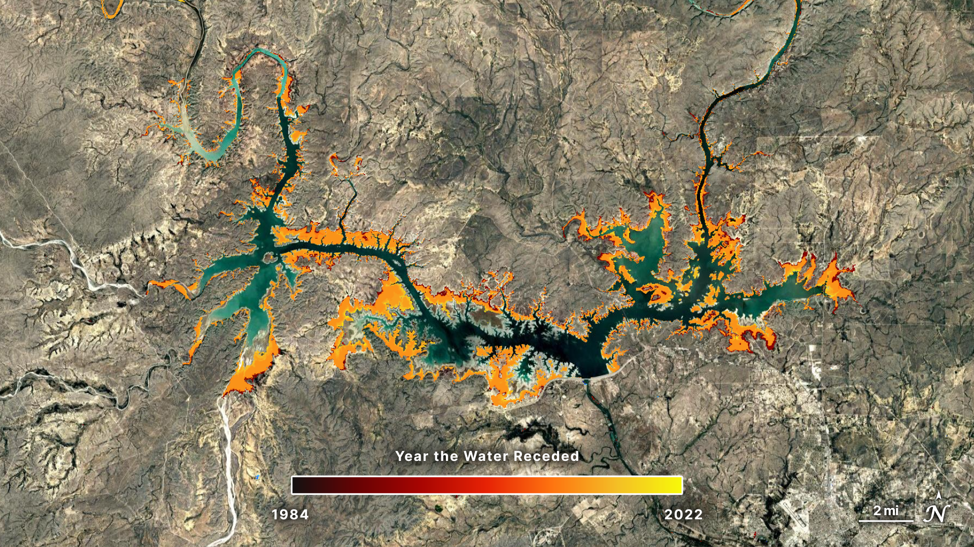
Researchers from the University of Southampton used Landsat data to identify where water advanced or retreated from 1984 to 2022, creating the first global dataset pinpointing the exact year of permanent surface water changes—such as when a reservoir formed or a stream dried up. The study can track changes in streams as narrow as 30m and lakes as small as 900m2. In a separate study, Texas A&M University researchers used Landsat data to build a global bathymetry dataset called ‘3D-LAKES’ that enables...
Article topics
Related articles

Humanoid Robot Pemba Climbs Chimborazo, Sets Sights on Everest Summit
The humanoid robot Pemba, an adaptation of the Unitree G1, recently ascended over 6,000 meters on Chimborazo and now aims to conquer Mount Everest. This technological feat paves the way for new forms of exploration in extreme environments.

Artemis III Progresses to Moon with Crucial Challenges and Mars Ambitions
NASA's Artemis III mission aims for a sustained human presence on the Moon, navigating delays in space suit development and technical hurdles with partners SpaceX and Blue Origin.

Stanford's STEHM Model Optimizes Search for Habitable Exoplanets
Stanford University introduces STEHM, a new tool that filters exoplanets based on their ability to maintain stable atmospheres, a key condition for life.
Latest news
View all
Elon Musk Plans Space Data Centers to Ease AI Energy Crisis
The escalating energy demand for artificial intelligence and terrestrial data centers is driving SpaceX to explore space-based solutions, with Starship being key to economic viability.

US Government Suspends Access to Anthropic's Fable 5 and Mythos 5 AI Models
A national security directive forces Anthropic to disable its advanced AI models, Fable 5 and Mythos 5, for all customers starting June 12, 2026.

Google Launches Gemini 3.5 Live Translate for Instant Voice Translation
Google expands real-time translation availability with Gemini 3.5 Live Translate, offering lower latency and support for over 70 languages.
Comments (0)
No comments yet. Be the first!
Leave a comment